|
PLANNING COMMISSION REPORT Regular Agenda – Public Hearing Item |
PC Staff Report
12/14/05
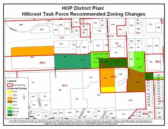
ITEM NO. 24: C-5 TO RO-1; .84 ACRES; NORTHEAST CORNER OF FLORIDA AND W. 7TH STREET (MJL)
Z-10-74-05: A request to rezone a tract of land approximately .84 acres from C-5 (Limited Commercial) District to RO-1 (Residence-Office) District. The property is generally described as being located at the northeast corner of Florida and W. 7th Streets (616, 620, and 624 Florida Street). Initiated by the City Commission on 10/25/05, based on recommendations in the HOP District Plan.
|
STAFF RECOMMENDATION: Staff recommends approval of rezoning approximately .84 acres from the C-5 District to the RO-1 District and forwarding it to the City Commission with a recommendation for approval based on the findings of fact found in the body of the staff report. |
|
|
Reasons for Request: |
To follow the recommendations of the HOP District Plan to zone property to the current use based on the neighborhood association task force study and recommendation. |
|
KEY POINTS
|
|
GOLDEN FACTORS TO CONSIDER CHARACTER OF THE AREA
CONFORMANCE WITH HORIZON 2020
|
|
ASSOCIATED CASES/OTHER ACTION REQUIRED · Z-10-68-05: C-5 to RM-2; 3.13 acres; between W. 6th and W. 7th Streets, east of Iowa Street · Z-10-69-05: RM-2 to RO-1B; 4.41 acres; north of W. 7th Street, west of Wisconsin Street · Z-10-70-05: RM-2 to RO-1A; 1.60 acres; between W. 7th and W. 6th Streets, east of Wisconsin Street · Z-10-71-05: RM-2 to RO-2; 2.27 acres; north of W. 7th Street, west of Florida Street · Z-10-72-05: RM-3 to RM-2; 2.19 acres; south of W. 7th Street, east of Wisconsin Street · Z-10-73-05: RM-3 to RS-2; .70 acres; north of the intersection of W. 8th Street and Avalon Road · Z-10-75-05: C-5 to RO-1A; 2.02 acres; northwest intersection of Michigan and W. 7th Streets, south of W. 7th Street between Michigan and Arkansas Streets · Z-10-76-05: C-5 to RM-3; 3 acres; southeast intersection of W. 7th Street and Lynch Court · Z-10-77-05: C-5 to RO-2; .51 acres; southwest corner of Michigan and W. 7th Streets |
|
PUBLIC COMMENT RECEIVED PRIOR TO PRINTING
|
|
GENERAL INFORMATION |
|
|
Current Zoning and Land Use: |
C-5 District; apartment complex (26 units)
|
|
Surrounding Zoning and Land Use:
|
C-5 (General Commercial) District to the north, south and east; club and retail store, a triplex and apartment complex (72 units), 5 units of multiple-family
RM-2 District (Multiple-family residential) District and C-4 (General Commercial) District to the west; single-family home (RM-2), dry cleaner, bookstore, an office
|
I. ZONING AND LAND USES OF SURROUNDING PROPERTIES
The property directly to the north of the subject property is zoned C-5 is developed with a club and retail store. The properties to the south are zoned C-5 and are developed with a triplex and an apartment complex. The property to the east of the subject property is zoned C-5 and is developed with four structures which include five units. The properties to the west of the subject property are zoned C-4 and RM-2. The property zoned C-4 is developed with a dry cleaner, bookstore and an office. The property zone RM-2 is developed with a single-family home.
Staff Finding – The request is to rezone approximately .84 acres from the C-5 District to the RO-1 District. The subject property is currently developed with a 26 unit apartment complex. The areas surrounding the subject properties are zoned C-5 District, C-4 District, and RM-2 District. As part of the HOP District Plan recommendations, the neighborhoods were to study the relationship of the land use and the zoning of the properties identified in the plan, which are included in the particular neighborhood association and located within the study area of the HOP District Plan. The plan recommended that zoning be updated to reflect the current use.
II. CHARACTER OF THE AREA
Staff Finding – The area is characterized by a variety of densities of residential uses, office uses, and commercial uses. The parcels directly surrounding the subject property are zoned for commercial and residential uses. The subject property acts as a transition between lower-density residential and the commercial uses along W. 6th Street.
III. SUITABILITY OF SUBJECT PROPERTY FOR THE USES TO WHICH IT HAS BEEN RESTRICTED
The subject property is currently zoned for commercial use. According to the City’s Zoning Ordinance, the C-5 District, requires a minimum lot area of 15,000 square feet and requires a minimum of 1,000 square feet per dwelling unit (43 units per acre) for residential development. The general purpose of the limited commercial district is “…to permit and encourage the grouping, in defined areas along highways, of certain retail activities and services intended primarily to serve, and be dependent upon, the motoring public. ”
The request is to rezone the subject property to the RO-1 District, which requires a minimum lot area of 6,000 square feet and requires a minimum of 1,000 square feet per dwelling unit (43 units per acre) for residential development. The general purpose of the residence-office district is “…to primarily provide mixed use areas for professional offices, medical, and dental clinics and similar types of uses that are compatible with and can be located adjacent to or in combination with single, duplex, or multiple-family residential uses without undue harmful effects to the residential uses.”
Staff Finding – Currently the properties are zoned C-5 developed with a 26 unit apartment complex. The RO-1 zoning would allow the same residential density as the C-5 District of up to 43 units per acre while also allowing professional office uses, subject to any additional applicable regulation in the Zoning Ordinance. The RO-1 District is more suitable, based on its purpose statement, than the C-5 District is for this property, which forms a transition between the W. 6th Street commercial uses and the Hillcrest neighborhood to the south.
IV. LENGTH OF TIME SUBJECT PROPERTY HAS REMAINED VACANT AS ZONED
Staff Finding - The subject properties have been zoned C-5 since the adoption of the 1966 City of Lawrence Zoning Ordinance.
V. EXTENT TO WHICH REMOVAL OF RESTRICTIONS WILL DETRIMENTALLY AFFECT NEARBY PROPERTY
Staff Finding –The RO-1 District is consistent with the existing development but is more restrictive as far as allowed uses. The proposed zoning allows residential and professional office uses. The proposed zoning would permit an appropriate transition between the commercial uses along W. 6th Street and residential uses on the south side of W. 7th Street. The proposed zoning would not detrimentally affect the nearby properties.
VI. RELATIVE GAIN TO THE PUBLIC HEALTH, SAFETY AND WELFARE BY THE DESTRUCTION OF THE VALUE OF THE PETITIONER’S PROPERTY AS COMPARED TO THE HARDSHIP IMPOSED UPON THE INDIVIDUAL LANDOWNERS
Evaluation of this criterion includes weighing the benefits to the public versus the benefit of the owners of the subject property. Benefits are measured based on anticipated impacts of the rezoning request on the public health, safety, and welfare.
Staff Finding – If the property retains its C-5 District designation, it could redevelop with the current residential density and a variety of high-density, auto orientated commercial uses. The proposed RO-1 zoning will lower the allowed uses while retaining the maximum residential density and offer options for future redevelopment of profession offices. Approval of the rezoning request will protect the public health, safety, and welfare by ensuring that high-traffic commercial uses will not filter into the neighborhood but multiple-family residential and/or office will maintain a transition between the commercial, highway, and lower-density residential uses.
VII. CONFORMANCE WITH THE COMPREHENSIVE PLAN
The subject property is located north of W. 7th Street and east of Florida Street. The following Horizon 2020 goal and associated policies support the rezoning application:
RESIDENTIAL LAND USE GOALS AND POLICIES
Medium-and Higher-Density Residential Land Use
GOAL 3: Compatible Transition from Medium and Higher Density Residential Development to both More Intensive and Less Intensive Land Uses (Page 5-25)
Policy 3.1: Use Appropriate Transitional Methods (Page 5-25)
Policy 3.2: Medium-Density Residential Development as Transitional Use (Page 5-26)
Staff Finding – The rezoning conforms to several Horizon 2020 policies related to medium and higher-density residential uses. This property will act as transition between the commercial and residential uses. The process of the HOP District Plan and implementation of the plan has allowed the neighborhood to update the zoning of the area to match the current use. The subject property’s rezoning will allow for the appropriate transitions in the area between the commercial uses along W. 6th Street and residential uses along W. 7th Street.
STAFF REVIEW
The subject property is located north of W. 7th Street and east of Florida Street. As previously stated, land uses surrounding the property include a single-family home, office uses, commercial uses, and multiple-family residential. The proposed zoning will be consistent with the current use and allow redevelopment as a residential use and/or a professional office use, subject any applicable regulations in the Zoning Ordinance. It is important to note that the application conforms to several Horizon 2020 policies.