|
PLANNING COMMISSION REPORT Regular Agenda – Public Hearing Item |
PC Staff Report
12/14/05
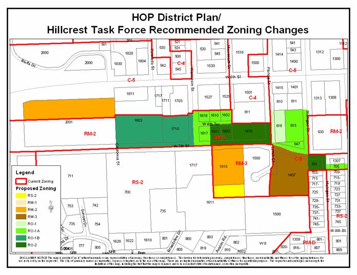
ITEM NO. 23: RM-3 TO RS-2; .70 ACRES; NORTH OF INTERSECTION OF W. 8TH STREET AND AVALON ROAD (MJL)
Z-10-73-05: A request to rezone a tract of land approximately .70 acres from RM-3 (Multiple-Family Residential) District to RS-2 (Single-Family Residential) District. The property is generally described as being located north of the intersection of W. 8th Street and Avalon Road (1611 W. 8th Street [northwest portion]). Initiated by the City Commission on 10/25/05, based on recommendations in the HOP District Plan.
|
STAFF RECOMMENDATION: Staff recommends approval of rezoning approximately .70 acres from the RM-3 District to the RS-2 District and forwarding it to the City Commission with a recommendation for approval based on the findings of fact found in the body of the staff report. |
|
|
Reasons for Request: |
The property owner requested inclusion in rezonings to consolidate property under single zoning district.
HOP study area extended 100’ south of W. 7th Street and did not originally include this property. |
|
KEY POINTS
|
|
GOLDEN FACTORS TO CONSIDER CHARACTER OF THE AREA
CONFORMANCE WITH HORIZON 2020
|
|
ASSOCIATED CASES/OTHER ACTION REQUIRED · Z-10-68-05: C-5 to RM-2; 3.13 acres; between W. 6th and W. 7th Streets, east of Iowa Street · Z-10-69-05: RM-2 to RO-1B; 4.41 acres; north of W. 7th Street, west of Wisconsin Street · Z-10-70-05: RM-2 to RO-1A; 1.60 acres; between W. 7th and W. 6th Streets, east of Wisconsin Street · Z-10-71-05: RM-2 to RO-2; 2.27 acres; north of W. 7th Street, west of Florida Street · Z-10-72-05: RM-3 to RM-2; 2.19 acres; south of W. 7th Street, east of Wisconsin Street · Z-10-74-05: C-5 to RO-1; .84 acres; northeast corner of Florida and W. 7th Streets · Z-10-75-05: C-5 to RO-1A; 2.02 acres; northwest intersection of Michigan and W. 7th Streets, south of W. 7th Street between Michigan and Arkansas Streets · Z-10-76-05: C-5 to RM-3; 3 acres; southeast intersection of W. 7th Street and Lynch Court · Z-10-77-05: C-5 to RO-2; .51 acres; southwest corner of Michigan and W. 7th Street |
|
PUBLIC COMMENT RECEIVED PRIOR TO PRINTING
|
|
GENERAL INFORMATION |
|
|
Current Zoning and Land Use: |
RS-2 District; single-family home
|
|
Surrounding Zoning and Land Use:
|
RM-3 (Multiple-Family Residence) District and RS-2 District to the north; two single-family homes
RS-2 District to the south; single-family residential
RM-3 (Multiple-Family Residence) District and RS-2 District to the east; apartment complex (67 units) and a vacant lot
RS-2 (Single-Family Residence) District to the west; large lot single-family residential uses. |
I. ZONING AND LAND USES OF SURROUNDING PROPERTIES
The properties directly north of the subject property are zoned RM-3 District and RS-2 District both of which are developed with single-family homes. The properties to the south of the subject property is zoned RS-2 and are developed with a single-family homes. The properties to the west of the subject property are zoned RS-2 and are developed with single-family homes. The properties to the east of the subject property are zoned RM-3 and RS-2. The property zoned RM-3 is developed with an apartment complex and the property zoned RS-2 is undeveloped.
Staff Finding – The request is to rezone approximately .7 acres of a 5.5 acre piece of property from the RM-3 District to the RS-2 District. The subject property is currently developed with a single-family home. The areas surrounding the subject property is zoned RS-2 District and RM-3 District. As part of the HOP District Plan recommendations, the neighborhoods were to study the relationship of the land use and the zoning of the properties identified in the plan, which are included in the particular neighborhood association and located within the study area of the HOP District Plan. This property was not included in the plan but is directly adjacent to the study area. With the adjacent property to the north being proposed to be rezoned, it is appropriate to rezone the remaining portion of the RM-3 District (northeast corner of the subject property) to the current use of the property and not leave a .7 acre section of land zoned differently in the middle of the area.
II. CHARACTER OF THE AREA
Staff Finding – The area is characterized by a variety of densities of residential use. The parcels directly surrounding the subject property are zoned for low and high-density residential uses. The subject property abuts high-density residential property in a back-to-back fashion and acts like a transition between low-density residential neighborhoods to the south and high-density residential uses to the north.
III. SUITABILITY OF SUBJECT PROPERTY FOR THE USES TO WHICH IT HAS BEEN RESTRICTED
The subject properties are currently zoned for residential use. According to the City’s Zoning Ordinance, the RM-3 District, requires a minimum lot area of 6,000 square feet and requires a minimum of 1,000 square feet per dwelling unit (43 units per acre) for residential development. The general purpose of the multiple-family residential district is “…to provide areas for medium and high population density.”
The request is to rezone the subject property to the RS-2 District, which requires a minimum lot area of 7,000 square feet and requires a minimum of 7,000 square feet per dwelling unit for residential development. The general purpose of the single-family residential district is that they “…are designed for those areas where the land is presently being used, or where development appears desirable, for single-family dwellings.”
Staff Finding – Currently the northeast portion of the subject property is zoned RM-3 where the remainder of the property is zoned RS-2 and the entire property is developed with a single-family home. The RS-2 zoning would allow consolidation of zoning for one zoning lot to the RS-2 District and be consistent with the current use.
IV. LENGTH OF TIME SUBJECT PROPERTY HAS REMAINED VACANT AS ZONED
Staff Finding – The northeast portion of the subject property has been zoned RM-3 since the adoption of the 1966 City of Lawrence Zoning Ordinance.
V. EXTENT TO WHICH REMOVAL OF RESTRICTIONS WILL DETRIMENTALLY AFFECT NEARBY PROPERTY
Staff Finding –The RS-2 District is more restrictive as far as residential densities than the current zoning. The proposed zoning allows single-family residential uses. The proposed zoning would allow one property to be consistently zoned. The proposed zoning would not detrimentally affect the nearby properties by helping protect the single-family character of the area to the west and south.
VI. RELATIVE GAIN TO THE PUBLIC HEALTH, SAFETY AND WELFARE BY THE DESTRUCTION OF THE VALUE OF THE PETITIONER’S PROPERTY AS COMPARED TO THE HARDSHIP IMPOSED UPON THE INDIVIDUAL LANDOWNERS
Evaluation of this criterion includes weighing the benefits to the public versus the benefit of the owners of the subject property. Benefits are measured based on anticipated impacts of the rezoning request on the public health, safety, and welfare.
Staff Finding – If the property retains its RM-3 District designation, that portion of the property could redevelop with a residential density of 43 units per acre. The proposed RS-2 zoning will lower the permitted residential density on that portion of the property and allow one zoning lot to be consistently zoned. Approval of the rezoning request will protect the public health, safety, and welfare by ensuring that multiple-family residential uses will remain in their current locations.
VII. CONFORMANCE WITH THE COMPREHENSIVE PLAN
The subject property is located north of the intersection of W. 8th Street and Avalon Road. The following Horizon 2020 goal and associated policies support the rezoning application:
RESIDENTIAL LAND USE GOALS AND POLICIES
Low-Density Residential Land Use
GOAL 3: Neighborhood Conservation (Page 5-14)
Policy 3.2: Protect Existing Housing Stock (Page 5-14)
GOAL 6: Compatible Transition from Low-Density Residential Development to More Intensive Land Uses (Page 5-19)
Policy 6.1: Use Appropriate Transitional Methods (5-19)
Staff Finding – The rezoning conforms to several Horizon 2020 policies related to low-density residential uses. The rezoning will help to protect the character of the neighborhood by protecting its appearance and by protecting existing housing stock. This property will act as transition between high and low-density residential uses with a back-to-back relationship.
STAFF REVIEW
The subject property is located north of the intersection of W. 8th Street and Avalon Road. As previously stated, land uses surrounding the property include single-family and multi-family residential. The proposed zoning will allow the subject property to be one zoning consistent with the current land use. It is important to note that the application conforms to several Horizon 2020 policies.