|
PLANNING COMMISSION REPORT Regular Agenda – Public Hearing Item |
PC Staff Report
12/14/05
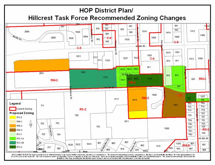
ITEM NO. 22: RM-3 TO RM-2; 2.19 ACRES; SOUTH OF W. 7TH STREET EAST OF WISCONSIN STREET (MJL)
Z-10-72-05: A request to rezone a tract of land approximately 2.19 acres from RM-3 (Multiple-Family Residential) District to RM-2 (Multiple-Family Residential) District. The property is generally described as being located south of W. 7th Street; east of Wisconsin Street (1515 W. 7th Street). Initiated by the City Commission on 10/25/05, based on recommendations in the HOP District Plan.
|
STAFF RECOMMENDATION: · Staff recommends denial of rezoning approximately 2.19 acres from the RM-3 District to the RM-2 District. · Staff recommends the Planning Commission initiate the rezoning of the subject property from RM-3 to RM-1. |
|
|
Reasons for Request: |
To follow the recommendations of the HOP District Plan to zone property to the current use based on the neighborhood association task force study and recommendation.
The property owner has indicated willingness to downzone within the multi-family group only. |
|
KEY POINTS
|
|
GOLDEN FACTORS TO CONSIDER CHARACTER OF THE AREA
CONFORMANCE WITH HORIZON 2020
|
|
ASSOCIATED CASES/OTHER ACTION REQUIRED · Z-10-68-05: C-5 to RM-2; 3.13 acres; between W. 6th and W. 7th Streets, east of Iowa Street · Z-10-69-05: RM-2 to RO-1B; 4.41 acres; north of W. 7th Street, west of Wisconsin Street · Z-10-70-05: RM-2 to RO-1A; 1.60 acres; between W. 7th and W. 6th Streets, east of Wisconsin Street · Z-10-71-05: RM-2 to RO-2; 2.27 acres; north of W. 7th Street, west of Florida Street · Z-10-73-05: RM-3 to RS-2; .70 acres; north of the intersection of W. 8th Street and Avalon Road · Z-10-74-05: C-5 to RO-1; .84 acres; northeast corner of Florida and W. 7th Streets · Z-10-75-05: C-5 to RO-1A; 2.02 acres; northwest intersection of Michigan and W. 7th Streets, south of W. 7th Street between Michigan and Arkansas Streets · Z-10-76-05: C-5 to RM-3; 3 acres; southeast intersection of W. 7th Street and Lynch Court · Z-10-77-05: C-5 to RO-2; .51 acres; southwest corner of Michigan and W. 7th Street |
|
PUBLIC COMMENT RECEIVED PRIOR TO PRINTING
|
|
GENERAL INFORMATION |
|
|
Current Zoning and Land Use: |
RM-3 District; single-family
|
|
Surrounding Zoning and Land Use:
|
RM-2 (Multiple-Family Residence) District to the north; two duplexes, single-family home
RS-2 (Multiple-Family Residence) District to the south; lot single-family home
RS-2 (Single-Family Residence) District to the west; single-family homes.
RM-3 (Multiple-Family Residence) District to the east; apartment complex (67 units) |
I. ZONING AND LAND USES OF SURROUNDING PROPERTIES
The property directly north of the subject property is zoned RM-2 District and is developed with and two duplexes and a single-family home (proposed to be rezoned to RO-1B). The property to south of the subject property is zoned RM-2 (northeast portion) and is developed with a single-family home (proposed to be rezoned to RS-2). The property to the west of the subject property is zoned RS-2 and is developed with a single-family home. The property to the east of the subject property is zoned RM-3 and is developed with an apartment complex.
Staff Finding – The request is to rezone approximately 2.19 acres from the RM-3 District to the RM-2 District. The subject property is currently developed with a single-family home. The areas surrounding the subject properties are zoned RS-2 District, RM-3 District and RM-2 District. As part of the HOP District Plan recommendations, the neighborhoods were to study the relationship of the land use and the zoning of the properties identified in the plan, which are included in the particular neighborhood association and located within the study area of the HOP District Plan. The plan recommended that zoning be updated to incorporate appropriate transitions between uses. The neighborhood recommended rezoning to RM-2, however in staff’s opinion, the RM-1 District would provide more of a transition between the existing uses and still provide the property owner with some redevelopment potential.
II. CHARACTER OF THE AREA
Staff Finding – The area is characterized by a variety of densities of residential use. The parcels directly surrounding the subject property are zoned for a variety of densities of residential use. The subject property is to act like a transition between low-density residential and high-density residential uses.
III. SUITABILITY OF SUBJECT PROPERTY FOR THE USES TO WHICH IT HAS BEEN RESTRICTED
The subject properties are currently zoned for residential use. According to the City’s Zoning Ordinance, the RM-3 District, requires a minimum lot area of 6,000 square feet and requires a minimum of 1,000 square feet per dwelling unit (43 units per acre) for residential development. The general purpose of the multiple-family residential district is “…to provide areas for medium and high population density.”
The request is to rezone the subject property to the RM-2 District, which requires a minimum lot area of 6,000 square feet and requires a minimum of 2,000 square feet per dwelling unit (21 units per acre) for residential development. The general purpose of the multiple-family residential district is “…to provide areas for medium and high population density.”
Staff Finding – Currently the property is zoned RM-3 and developed with a single-family home. The RM-2 zoning would allow residential redevelopment up to 21 units per acre, subject to any additional applicable regulation in the Zoning Ordinance.
The RM-1 District is more appropriate for this property to form a transition between low-density residential that is abutting the subject property to the west and south and higher-density residential uses to the north and east. The RM-1 District zoning is also consistent in residential density with the proposed zonings across W. 7th Street of RO-1B District. The proposed zoning of property to the north of the subject property would have the same residential density as the RM-1 District but the properties to the north of the subject property would have the ability to redevelop as office uses in addition to the residential uses.
IV. LENGTH OF TIME SUBJECT PROPERTY HAS REMAINED VACANT AS ZONED
Staff Finding - The subject property has been zoned RM-3 since the adoption of the 1966 City of Lawrence Zoning Ordinance.
V. EXTENT TO WHICH REMOVAL OF RESTRICTIONS WILL DETRIMENTALLY AFFECT NEARBY PROPERTY
Staff Finding –The RM-2 District is more restrictive as far as residential densities than the current zoning. The proposed zoning allows residential uses. The proposed zoning would not detrimentally affect the nearby properties.
The RM-1 District zoning would also be more restrictive than the current zoning but would be a more appropriate transition between abutting uses.
VI. RELATIVE GAIN TO THE PUBLIC HEALTH, SAFETY AND WELFARE BY THE DESTRUCTION OF THE VALUE OF THE PETITIONER’S PROPERTY AS COMPARED TO THE HARDSHIP IMPOSED UPON THE INDIVIDUAL LANDOWNERS
Evaluation of this criterion includes weighing the benefits to the public versus the benefit of the owners of the subject property. Benefits are measured based on anticipated impacts of the rezoning request on the public health, safety, and welfare.
Staff Finding – If the property retains its RM-3 District designation, it could redevelop with a residential density of 43 units per acre. The proposed RM-2 zoning will lower the permitted residential density but not provided an appropriate transition between uses.
The RM-1 District would create a more appropriate transition between the adjacent residential density extremes and be consistent with the residential density for the proposed zoning across W. 7th Street. This zoning however would reduce the maximum density for redevelopment to 12 units per acre. The RM-1 District would protect the public health, safety, and welfare better by creating appropriate transitions of medium-density residential and not creating the opportunity for high traffic residential development, which could harm the neighborhood, to occur in the future.
VII. CONFORMANCE WITH THE COMPREHENSIVE PLAN
The subject property is located on the south side of W. 7th Street west of Florida Street. The following Horizon 2020 goal and associated policies support the rezoning application:
RESIDENTIAL LAND USE GOALS AND POLICIES
Medium-and Higher-Density Residential Land Use
GOAL 3: Compatible Transition from Medium and Higher Density Residential Development to both More Intensive and Less Intensive Land Uses (Page 5-25)
Policy 3.1: Use Appropriate Transitional Methods (Page 5-25)
Policy 3.2: Medium-Density Residential Development as Transitional Use (Page 5-26)
Staff Finding – The rezoning conforms to Horizon 2020 policies related to medium, and higher-density residential uses. The proposed zoning would not act as an appropriate transition between the high and low-density residential uses in the area.
The process of the HOP District Plan and implementation of the plan has allowed the neighborhood to update the zoning of the area to create appropriate transitions between uses.
STAFF REVIEW
The subject property is located on the south side of W. 7th Street west of Florida Street. As previously stated, land uses surrounding the property include a variety of densities of residential uses. The proposed zoning will allow redevelopment as a high-density residential use subject any applicable regulations in the Zoning Ordinance.
Staff finds that a zoning of RM-1 District would be more appropriate as a transitional zoning between the different densities of residential uses. The RM-1 District zoning would be consistent with the residential density of the proposed zoning of the properties across W. 7th Street to the north from the subject property. The RM-1 District would also be more appropriate as a transition between the high-density residential property to the east of the subject property and the low-density residential uses to the south and west of the subject property. Horizon 2020 identifies the subject property on the future land use map as a medium-density residential use. The RM-1 District would also create less potential for a large increase in traffic if redevelopment as a multiple-family residential use was to occur.