NON-PUBLIC HEARING ITEM:
ITEM NO. 2: FINAL PLAT FOR STONE MEADOWS-WEST NO. 4 SUBDIVISION; WEST OF STONEMEADOWS DRIVE (SLD)
SUMMARY
PF-01-02-04: Final Plat for Stone Meadows-West No. 4 Subdivision, a Replat of a portion of Lot 6, Block 3, Stone Meadows-West Subdivision, and Lots 7A and 8A, Sandy’s Subdivision, a Replat of Lots 7, 8, 12 & 13, Block 3, Stone Meadows-West Subdivision. This proposed residential subdivision contains approximately 1.10 acre and is located west of Stone Meadows Drive. Submitted by Taylor Design Group for Garber Enterprises, Inc., property owner of record.
GENERAL INFORMATION
Current Zoning and Land Use: RM-1 (Multiple-Family Residence) District; existing multi-family development
Surrounding Zoning and Land Use: RM-1 (Multiple-Family Residence) District to the east, west and south, existing multi-family development.
RS-2 (Single-Family Residence) District to the north; existing single-family residential development.
Site Summary
Number of Lots: 3 existing developed lots
Gross Area: 1.10 acre
Proposed number of Lots: 1 consolidated lot
Rights-of-way: No additional right-of-way proposed
Access Easements: Separate agreement to be recorded
REVIEW COMMENTS FROM OTHER DEPARTMENTS/AGENCIES:
Planning Department:
1. Revise Planning Chairperson endorsement block to “David Burress” (Revised).
2. Provide copy of access and maintenance agreement for file. (Applicant notified).
1. Provide graphic line between centerline of adjacent street and property line (revised).
2. Show existing adjacent easements. (Revised).
3. Provide additional utility easement along east and west property lines (revised).
4. Note referencing original lot line should include “Sandy’s Subdivision” (revised).
5. General note regarding title insurance policy is not applicable to this subdivision (revised).
6. Correct street name is Brighton Circle per Ordnance 5849 (revised).
Stormwater Engineer: A drainage study will not be required for this plat. The increase in impervious surface is less than 10%. The Final Plat dated 01-14-04 meets the specified requirements.
Traffic Engineering: No Comments
Municipal Utilities: No Comments
Neighborhood Resources:
1. Send email to Tim Pinnick regarding any lot restrictions (staff follow-up item after approval).
2. Include street tree right of entry note on face of document (Not applicable to the RM-1 District).
Parks/Rec:
1. Provide master street tree plan and/or show trees already planted (condition of approval).
2. Please provide temporary right of entry note on plat for Planning (Not applicable to the RM-1 District).
Fire Department: No Comments
Police Department: No Comments Provided
Westar: No Comments
Aquila: No Comments Provided
Southern Star Central Gas: No Comments Provided
Southwestern Bell: No Comments
STAFF REVIEW
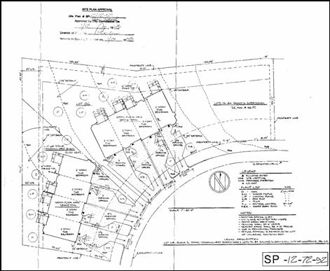
The subject property is a developed subdivision that includes apartment type buildings. The subject property is located along Brighton Circle just north of W. 15th Street. The proposed plat consolidates three existing lots into a single lot to remove the interior lot lines. The two western buildings were constructed in 1993 according to the Appraiser’s Office (SP-12-72-92). The 1992 site plan only approved the construction of the two 4-plex buildings. The triplex building appears to have been constructed in November of 1993. A triplex would not have required the submission of a site plan.
The property is zoned for multi-family uses. The multi-family housing was constructed as a single development under a single ownership and therefore was not required to conform to the interior lot lines. The current property owner has indicated a desire to sell individual units within the development and is re-platting to remove the interior lot line encumbrance.
The plat proposes to dedicate an additional utility easement along the south line of what is now Lot 6R. There are no interior utility easements that will be vacated by this plat.
Conformance
The RM-1 (Multiple-Family Residence) District requires 3,500 SF per dwelling unit (12.5 dwelling units per acre). There are 11 units on the total acreage. The zoning density based on lot area would allow a total of 13 dwelling units. The proposed lot configuration and size conforms to the existing zoning code. The overall lot depth and width conform to the minimum standards of the RM-1 District. There is no development/construction associated with this replat. The intent is to “clean-up” the lot configuration to allow for individual sale of dwelling units.
Recommendation: Staff recommends approval of the Final Plat of Stone Meadows-West #4 and forwarding it to the City Commission with a recommendation for acceptance of easements subject to the following conditions:
- Provision of a copy of the maintenance and access agreement to staff for the plat file; and
- Provision of the following fees and recording documentation:
a. Copy of paid property tax receipt;
b. Recording fees made payable to the Douglas County Register of Deeds;
c. Provision of a master street tree plan.
Copy of Approved site plan: